Our city is home to around 2,160 parks, from small suburban playgrounds to sweeping bushland reserves, each contributing to the unique character and ecosystem of the city.
MUSGRAVE PARK
Musgrave Park is located near the southern bank of the river in South Brisbane. It once had a waterhole from which Aboriginal people serviced the South Brisbane settlement with water supply. It is the last remaining remnant of the much larger South Brisbane Water and Recreation Reserve, which included sizable Aboriginal camps. The park has remained a deeply important cultural, networking and gathering place for Aboriginal people.
During a population boom in the 1860s, temporary tents in the park housed new migrants. It was a site for organised sport, including cricket, football and lawn tennis since the 1870s, and in 1884 it was named after then-Governor of Queensland, Sir Anthony Musgrave. A portion of the park was excised in 1922 for the building of Brisbane State High School, which still stands adjacent to the remaining park.
Musgrave Park today is an important site for cultural celebrations such as Paniyiri Greek Festival and NAIDOC Week, and it remains a hub of activism for Indigenous rights in South-East Queensland.
MOUNT COOT-THA
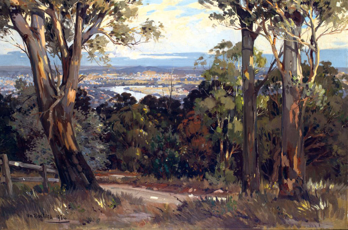
The summit of Mount Coot-tha is an Aboriginal Dreaming site and was rich with resources of firewood and native honey. The name comes from the Turrabul word ‘kuta’ or ‘gootcha’ which means ‘dark native honey’, ‘native bee’ and ‘club’ (the latter probably referring to wood used to make clubs). Mount Coot-tha boasts the highest peak in Brisbane and has become a popular location for tourists. As William Bustard captures in his painting Evening (Mt Coot-Tha) (1924), the summit offers sweeping views of the city and on a clear day, Moreton Bay.
Amongst Mount Coot-tha’s picturesque bushland is a quarry. Established in the 1890s to supply stone for Brisbane’s buildings, the quarry now supplies asphalt aggregate for the city’s road infrastructure. In 1976, after several major floods had destroyed plant life at the City Botanic Gardens, the Mount Coot-tha Botanic Gardens opened next to the quarry. Today, the Gardens contain more than 200,000 plants across 5,000 species.
SOUTH BANK PARKLANDS
The riverfront stretch of South Brisbane has undergone radical change over the last half-century. It began as an area of mosaic rainforest, cleared for corn fields to feed the penal colony.
South Brisbane became the thriving centre of Brisbane’s commerce from the 1850s until it was inundated by the 1893 flood. Businesses were relocated to the higher location on the north bank, now the site of the CBD, and South Brisbane became an industrial wharf area. Evidence of this can still be seen at the dry docks at the Queensland Maritime Museum.
This riverfront stretch transformed from industrial docklands and boarding houses to a cleared site in the lead up to World Expo 88, which attracted 18 million people. After Expo 88, much of the South Bank site remained parkland, with bike paths, walkways and a tropical lagoon constructed.